The Cape Horn Loop hike on the Washington side of the Columbia River Gorge is an excellent 7 mile long hike that is close to Portland and easy to get to. The hike starts just off Highway 14 roughly 10 miles east of Washougal and winds its way up the cliffs of the Columbia Gorge far above the highway offering excellent views and vista points. Along the trail you will pass waterfalls, cross creeks, meander through heavily wooded areas and be presented with numerous views of the gorge looking both east and west.
There are a few ways to hike Cape Horn and you will find that most people opt for the out and back trip making to the viewpoints then returning. This is a good option if you are looking for a shorter hike. For those looking for something a little more challenging opt for the longer 7 mile loop hike. *Note that the 7 mile loop hike is not possible from February to July due to a trail closure to protect nesting falcons.
Cape Horn Hike Trailhead

The Cape Horn Hike starts at the Cape Horn Trailhead located at the junction of Salmon Falls Road and Highway 14. There is a large parking lot that fills up quickly during the busy season and parking is free – no permit needed. Be sure to remove any valuables from your car as there have been many break-ins here. The trailhead has restrooms, a paved lot and information boards outlining the history of the area. To find the trailhead from the parking lot cross Salmon Falls Road and look for the Cape Horn Trail sign. You can’t miss it.
Cape Horn Trail – The Hike

Upon entering the trail you will immediately be greeted with junction where the trail goes left or right. Left is how you will return so stay right and follow the trail as it winds through the woods until you cross a small creek. After the creek crossing the trail begins to work its way uphill through a series of mild switchbacks. At this point it is important to note that this trail is open to horses and because of this you will come across many junctions with signs that say something like “viewpoint” or “horses only”. At no point do you want to follow the horse trails – these completely bypass the viewpoints and you will miss out on the main attractions of this hike. All of the “viewpoint” trails link back up with the main trail without forcing you to backtrack.
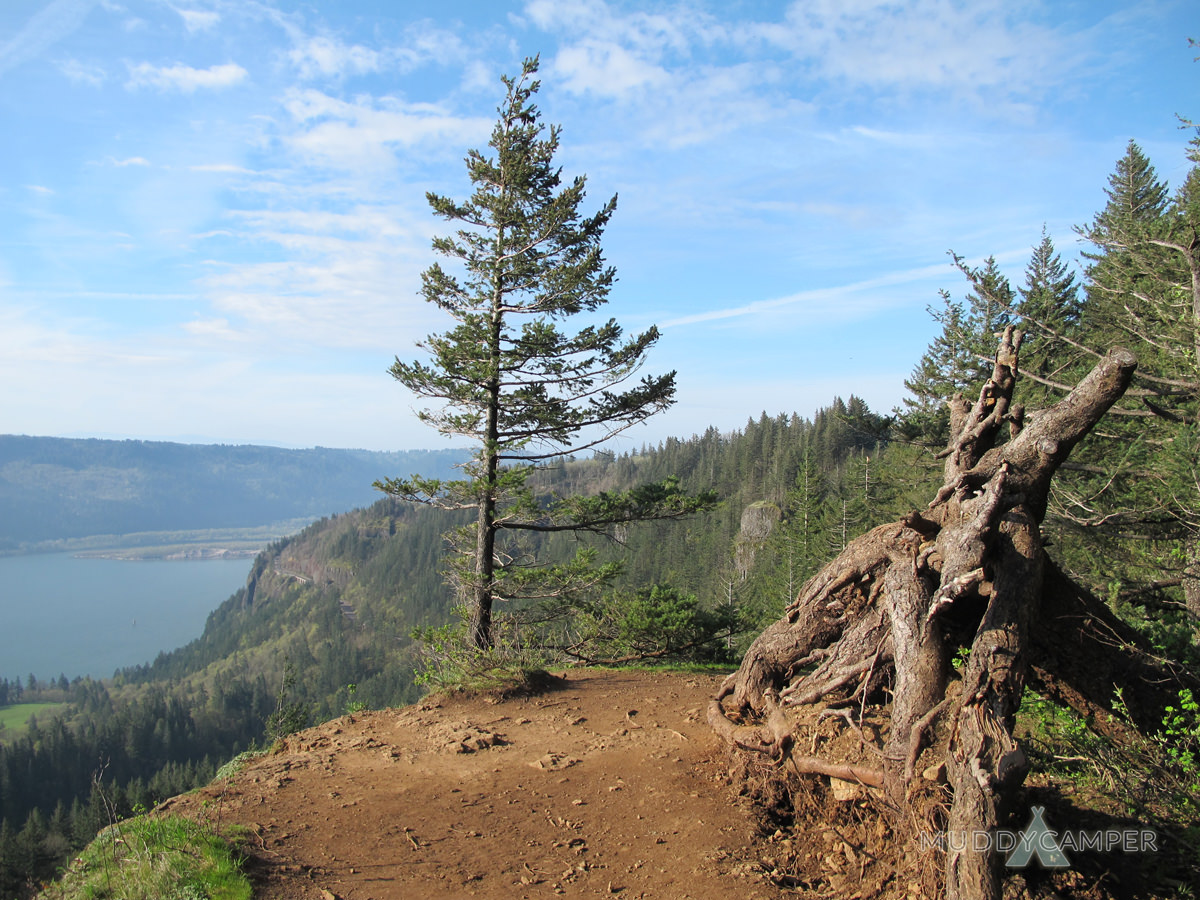
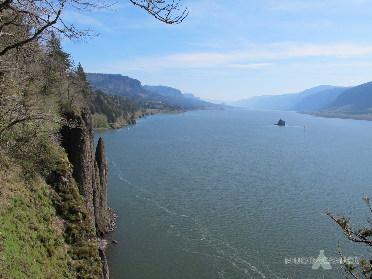
As the trail gets steeper you will soon reach your first view of the Gorge – Pioneer Point. The view here to the east is excellent but watch that ledge – one false step and it will be the last thing you see. Continue on the side trail here (do not back track) and you will quickly come to another viewpoint called Fall Tree Viewpoint which offers better views to the west as well as east.
Continue hiking on the side trail until you meet up again with the main trail and keep hiking up. You will soon work your way from the cliffs and come to a section of trail that crosses private property. It is OK though – the landowners have easement that allows access for well behaved hikers. Soon you will come to a dirt road with a gate. There are small brown markers with arrows indicating the direction of the trail for those who confuse easily. Follow the road until you will see some homes and soon the dirt road runs into a paved road you must cross called Strunk Road.
When you cross the road you will see a field with a trail working its way parallel to the road for a short ways until you come to a T. Stay right and follow the gravel road slightly downhill until you find the trail again on your left hand side. This is where the trail leads to your next viewpoint called Phoca Viewpoint.

This is a developed viewpoint that looks east up the Gorge and is a popular spot for photographers. If you are doing this hike between February and July this is a good turnaround point due to the closure further down the hill.
To continue the loop jump back on the trail and continue downhill for some time. You will eventually pass a old decaying shed that is located on the trail and soon after that you will begin to hear the noise from Highway 14. The trail will lead to a tunnel that passes under the highway as you get closer to another viewpoint that looks down on the upper portion of Cape Horn Falls. Enjoy the view then continue on your way as the trail meanders down to the Columbia River offering some amazing views along the cliffs and water’s edge.

Soon you will arrive at Cape Horn Falls proper which is really the middle tier of this long cascade of falls. There is a bridge that crosses the creek at the waterfall and then you will continue on the trail until you reach the end where the dirt meets asphalt. From this road you will have to hike out to your car – so from the trail be sure to turn left, away from the river. You will hike out on this paved road for about a mile until you get close to highway 14. Keep an eye out for another trail that jumps off the road and will take you through a tunnel under the highway and meets up with the original trailhead where you can find your hopefully undisturbed vehicle.
What to Bring
If you are doing the full 7 mile Cape Horn loop hike be sure to bring plenty of water and snacks. Proper hiking attire is suggested and if it is a windy day keep in mind you are headed to the gorge so it will be even windier there. You can get away with trail shoes however the latter portion of this hike crosses several rock falls so if you are prone to twisted ankles you may want to opt for boots on this one. The time it takes to complete this hike will vary but experienced hikers can expect to have this loop done in about 3 hours.
Where to Camp
If you are looking to camp near the Cape Horn trailhead consider camping at Beacon Rock State Park, Dougan Creek Campground, or Beaver Campground outside Carson, Washington.
Photos from the Cape Horn Hike
[justified_image_grid flickr_user=84922364@N06 flickr_photoset=72157666959233412 flickr_caching=10080]


Responses